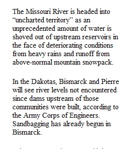
Q Media Writing Lab Online writing assignment – Assignment 2 This assignment has three parts. Make sure you complete all three. Applying what you’ve learned about the nature of online media writing, we’ll examine how to enhance an online newspaper story. Use the Omaha World-Herald’s story “Flooding coming, but how much?” that appears below. Assume you are enhancing this story, for readability and reader interest, at the time the story was written. Part 1 1. First, break the story into short, digestible pieces using subheadings. What sub-topics are embedded in the story? Use them as your guide. 2. Use bolded subheadings every few paragraphs (pick out a word, phrase or idea from what follows and express it in three to seven words). 3. You do not need to rewrite or reorganize the story. Part 2 1. Using the list below, choose four ways from the list below to enhance the story. 2. Place them in the appropriate place within the story. • Include three poll questions that related to the story • Include a link to audio. • Include a link to a video. • Make a bulleted list with story highlights/key points within the body of the story or as a side bar. • Insert a link to a story or outside websites with related content. • Copy and insert a map from another website (type in the name of the source) or insert the link to a map • Insert a picture or slideshow from another website or insert the link Part 3 At the end of your paper explain why you made each of your four choices and placed them where you did. ************************************************************************************************* (From Omaha World-Herald -- May 25, 2011) Flooding coming, but how much? By Nancy Gaarder and Kevin Cole World-Herald Staff Writers The Missouri River is headed into “uncharted territory” as an unprecedented amount of water is shoved out of upstream reservoirs in the face of deteriorating conditions from heavy rains and runoff from above-normal mountain snowpack. In the Dakotas, Bismarck and Pierre will see river levels not encountered since dams upstream of those communities were built, according to the Army Corps of Engineers. Sandbagging has already begun in Bismarck. “There's no good news,” said the corps' Jody Farhat. The releases will push river levels at Omaha near flood stage, which is 29 feet, she said. But that doesn't take into account any new rains, which would compound the problem. The stretch of river at greatest risk in the Midlands is from Plattsmouth south to just north of Kansas City, Farhat said. That's because of a combination of channel conditions and additional water flowing in from the Platte and Nishnabotna rivers. Urban areas on the lower Missouri, such as Omaha and Kansas City, Mo., are protected by flood walls and levees, but additional farmland, roads and recreational facilities in the region are likely to flood in coming weeks. The high waters could shut off at least one major route between Nebraska and Iowa and spell the end of the summer boating season before it begins along much of the Missouri River because marinas will have to close. Additionally, park facilities such as baseball and soccer fields, hiking and biking paths and campgrounds will most likely close if they haven't already. Late Tuesday afternoon, the Corps of Engineers announced that it would release record amounts of water from its dams, with the hope that even worse flooding can be avoided. “It moves us into uncharted territory,” Farhat said. The corps began boosting releases from three upstream reservoirs — Garrison, Oahe and Gavins Point — on Monday. For now, the targeted maximum release from Gavins Point is 85,000 cubic feet per second by June 3, with higher releases possible later. Gavins Point is the dam that affects Nebraska, Iowa and points south. An 85,000 cfs release from Gavins Point is about 20 percent more than the record of 70,000 cfs set in 1997, and it's about 50 percent more than was being released earlier this week. Farhat said the planned increase will result in roughly 3½ to 4 feet more water in the river along the Nebraska-Iowa border. The releases from Gavins Point could remain high until December. “It's unlikely to go down; it definitely could go up,” Farhat said. “This is an extreme event, and these huge flood events don't pass without having a significant impact,” she said. Sustained high river levels are bad news because the odds then favor even worse flooding when heavy rains fall. The current crisis was triggered by heavy rainfall in North Dakota, South Dakota and Montana over the past couple of weeks. Last weekend, some areas saw 8 inches of rain. But the wild card, and another reason the corps is moving so aggressively, is pent-up water in the mountain snowpack. Snowpack in the mountains usually peaks in mid-April, but this year it didn't peak until early May at around 140 percent of the normal high, according to the corps. Water released from Gavins Point takes about three days to reach Omaha and several more days to reach the Missouri border. That means the river should see its maximum effect from this release by about June 7 in Omaha. It's clear that recreational users of the river have been monitoring conditions. People already have been moving boats and RVs out of marinas and campgrounds, local managers say. Residents of Big Lake, Mo., across the river from Rulo, Neb., will most likely start hauling out their possessions, Village Clerk Diane Phillips said. Among the roads at risk of flooding is Highway 2, which connects Nebraska and Iowa at Nebraska City, said Mike Crecelius, Fremont County, Iowa, emergency manager. Water is already lapping at the shoulders, he said. “If you drive down Highway 2 now, it looks like you're going through the Everglades,” he said.
View Related Questions